


Improving Decision Making
Netafim offers uManage - the industry's most advanced real-time crop management decision support system (DSS). A centralized end-to-end software solution for open-field farmers and greenhouse operators, uManage covers all crop management processes - from planning andcontrol to monitoring and analysis. Leveraging Netafim's industry-leading experience and know-how, uManage ensures precise fertilization, optimizes resource usage, and controls irrigation scheduling leading to lower costs, greater efficiency and improved agricultural performance.
Designed for greenhouses and open fields, uManage continuously collects data from a wide range of field sensors. A user-friendly, browser-based solution, uManage enables technicians, engineers, agronomists and growers to access, input, cross-reference and share information anytime, anywhere. The solution also improves grower accountability by consolidating information through a secure and centralized platform that is easily accessible to farming personnel and other authorized users.
Part of Netafim's line of market-leading crop management technology (CMT) solutions, uManage complies with the world’s strictest industry standards. Fully supported by Netafim's experienced and professional service team, the reliable feature-rich solution helps growers to better manage their resources, produce more yields at lower costs, and boost profitability.
uManage Benefits
- Lower operational costs
- Optimized usage of resources
- Increased efficiency
- Greater grower accountability
- Improved crop quality and yields
- Enhanced revenues and profitability
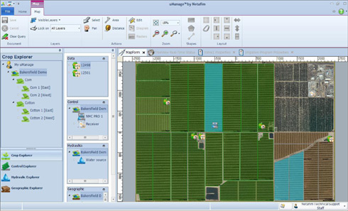
Multi-layered Gis System
Incorporating maps, satellite images, aerial images and other geographic data, uManage is an
advanced geographic information system (GIS) featuring four layers.
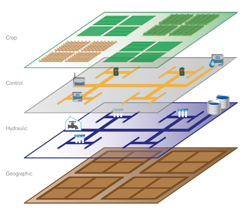
- Crop: indicates the location of seasonal and multi-seasonal crops along with their growth history and accompanying analysis
- Control: controls all field irrigation systems for use by selected technicians and project managers
- Hydraulic: indicates the location of all active field irrigation pipes, valves and water transport equipment, as well as relevant performance data (e.g. flow rate, pressure, pulse length)
- Geographic: maps out the field's exact geographic location and relevant factual information such as soil type, soil chemical composition and climatic conditions